
Sale!


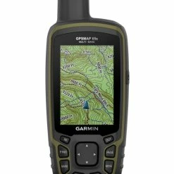


Garmin GPSMAP 65s
Original price was: $400.00.$97.99Current price is: $97.99.
- The quality solution for all your needs.
- Reliable Payments for Reliable Shopping
- Secure Shopping Starts with Safe Payments
- Safe Transactions, Always

Find your way through steep country, urban canyons and densely treed forests with the Garmin GPSMAP 65s, a rugged handheld with multi-band technology and expanded GNSS support.
Features
- Expanded global navigation satellite systems (GNSS) and multi-band technology help to track your route in challenging environments that would prove difficult for GPS alone
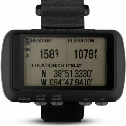
- Navigate every trail with ABC sensors, including an altimeter for elevation data, barometer to monitor weather and 3-axis electronic compass
- Large, sunlight-readable display measures 2.6 in. with 160 x 240 pixels to present imagery in crisp and colorful detail
- Connectivity via Bluetooth and ANT+ lets you share your waypoints, tracks, routes and geocaches wirelessly with other compatible devices
- Compatible with Garmin Explore™ website and app to help you manage tracks, routes and waypoints and review statistics from the field
- Includes routable TopoActive mapping and federal public land map
- IPX7 rating means this is considered waterproof; it can withstand submersion in water up to 1 m deep for up to 30 min.
Imported.
Technical Specs
| Best Use | Navigating |
|---|---|
| Preloaded Map | Topo |
| Basemap | Yes |
| Wireless Communication | Yes |
| OS Compatibility | Windows / Mac Android iOS |
| Display Size | 2.6 inches |
| Screen Pixels | 160 x 240 |
| Visual Map Display | Yes |
| Color Screen | Yes |
| Number of Routes | 200 |
| Number of Waypoints | 5000 |
| Internal Memory | 16 gigabytes |
| Expandable Memory | Yes |
| Compass | Yes |
| Altimeter | Pressure-based |
| Quad Helix Antenna | Yes |
| Compact Antenna | Yes |
| Position Accuracy | 3 meters |
| Battery Type | NiMH |
| Batteries | 2 AA |
| Average Battery Life | 16 hours |
| Dimensions | 6.3 x 2.4 x 1.4 inches |
| Water-Resistance Rating | IPX7 |
| Weight | 7.8 ounces |
| Color | Gray |
|---|
Be the first to review “Garmin GPSMAP 65s”
Related products
Sale!


Camp Electronics
Original price was: $600.00.$97.99Current price is: $97.99.
Sale!


Camp Electronics
Original price was: $350.00.$99.99Current price is: $99.99.
Sale!
Camp Electronics
Original price was: $200.00.$95.99Current price is: $95.99.
Sale!
Camp Electronics
Original price was: $319.99.$96.99Current price is: $96.99.
Sale!
Camp Electronics
Original price was: $500.00.$95.99Current price is: $95.99.
Sale!


Camp Electronics
Original price was: $400.00.$99.99Current price is: $99.99.
Sale!

Camp Electronics
Original price was: $400.00.$98.99Current price is: $98.99.
Sale!
Camp Electronics
Original price was: $532.00.$97.99Current price is: $97.99.
Reviews
There are no reviews yet.